- What are the elements of communication systems? Explain with classifications of communication systems
- What is the Frequency Spectrum of Communication Systems? Why Modulation is necessary in wireless transmission?
- What is Amplitude Modulation? Complete Mathematical Derivation of AM Wave
- What is the Importance of Side Bands in Amplitude Modulation? What are the types of AM?
- What is Frequency Modulation? Explain the process with diagram and mathematical analysis
- What is Satellite communication? Give Detailed explanation with diagram and mathematical analysis
Details of Satellite
- Satellite is an artificial revolving object around the earth.
- It contains different electronic communication systems.
- It is used for long distance communication purpose.
- A satellite is widely used for full duplex communication around the globe.
- It is also used for number of other applications like meteorological studies, observation and surveillance reporting, GPS communication, etc.
Geosynchronous satellite
The geosynchronous satellite orbits around the earth at a distance of about 36000km and it takes exactly 24 hours to complete its one revolution around earth. So it appears stationary at the location, from where it is launched.
It is mainly used for communication purpose to relay the signals from one location to another on earth. It is also known as geostationary satellite.
The transmitting antenna on earth is pointed towards the geosynchronous satellite. The satellite receives the signals, amplifies them and retransmits them back to earth by reducing its frequency.
Satellite Relay station
A geosynchronous satellite is used to relay the signals from one location on earth to another distant location. Due to curvature of earth globe, we cannot send the signals directly as they cannot be received beyond horizon.
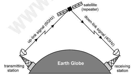
For this reason, we use satellite as relay station, as shown in following diagram –

The transmitting station sends powerful uplink signal (generally 6GHz). The satellite collects this signal and amplifies it.
Then it converts the uplink signal into low frequency down link signal (generally 4GHz) and retransmits it back to earth beyond horizon. So a very large area can be covered.
A transponder is used inside the satellite to amplify uplink signal and convert it into downlink signal. We shall study about the transponder on next page.
Transponder – advanced satellite communication system

As shown in above diagram a transponder consists of three sections: receiver section, processing section and the transmitter section.
Receiver section: It contains the receiving antenna, generally a dish antenna pointed towards earth at a particular location. It receives the uplink signal fs = 6GHz from earth. Then it is connected to low noise amplifier block (LNA) to amplify the signal strongly. The LNA amplifies the signal with high quality by rejecting noise.
Processing section: In this section, the amplified uplink signal fs = 6GHz is mixed in mixer circuit, with local oscillator frequency signal f0 = 2GHz. The mixer produces the difference of these two signals and produces the output as fs – fs = 2GHz.
Transmitter section: Now the 4GHz signal is ready to go back to earth. For that it is again strongly amplified by power amplifier. The power amplifier has high gain and large bandwidth. Then the downlink signal is connected to the retransmitting antenna to send it back to earth.
In this process the frequency of uplink signal is reduced to produce downlink signal. This process is called translation. The translation is necessary to avoid interference between transmitter and receiver within the transponder.
Applications of satellite
Satellite is mainly used in following applications –
Communication satellite
Majority of the satellites are used for radio communication from one country to another or within home country. It is used for broadcasting signals of entertainment TV channels, telephone calls, SATPHONE communication, etc. So it is used as relay station.
Surveillance & military satellite
It is used to keep an eye on the activities of other countries and enemies using video cameras and infrared (IR) cameras. The surveillance satellite also observes for nuclear tests activities, riots, jungles on fire, river floods, etc.
Meteorological satellite
This satellite is used for the studies of weather and its forecasting. The forecasting of Tsunami activities, cyclones, low/high pressure belts on sea shores, heavy rain or heavy snow warning, etc. is possible.
GPS satellites
It is a network of 24 satellites revolving around the earth globe. All these satellites constantly process the signals coming from the GPS systems used on earth. The signals from GPS systems are processed by these satellites and provide the information of exact location within ±100 meters.


